Back in Uganda, I looked over into the DRC and said it’d be about 15,000km before I got there. It’s been a little over 14,000km – so not a bad guess! The DRC is a huge country but I’ll just be cycling across a small part of it, the narrow corridor that links the vast interior to the coast.
First I had to get to the border, which took most of the morning. The tarmac disappeared after a few kilometres, replaced by fairly smooth dirt on the half-constructed road. Then it was onto the bumpy old road, which went over a series of hills.

As I got closer to the border, the names people yelled out to me started to change. I am now “Mbele.” In Angola, most people speak Portuguese as a first language. In the DRC, French is the administrative language but traditional languages are spoken at home.
A few kilometres before the border, I turned a corner and suddenly saw the river Congo ahead of me. It’s an impressive sight.

Downstream, the river forms the border between Angola and the DRC. Upstream, though, the border is in the hills on the southern side of the river, so I had a short climb to get there.

The Angolan border town, being quite distant from the rest of the country, has more in common with Matadi, the large Congolese city on the border. Thus locals pass freely, but the border sees few foreigners. On the Angolan side I had to search out the immigration officials.
They were friendly. The one I spoke to was very impressed I was cycling while another, who had presumably met other cycle tourists, asked if I was going all the way to Morocco. I said yes, which shocked the first official. They stamped me out quite quickly, and asked for some selfies with me. After stamping me out they checked my yellow fever and Covid vaccinations.
Over on the DRC side things were a little less orderly but the officials were friendly and showed me what I needed to do. My vaccinations were checked again, then I went off somewhere else and had my passport stamped. I was by instinct still replying in Portuguese rather than French, so most questions were answered with “Si – oui.”
After changing my money into Congolese Francs, I rode away from the border. There were quarries nearby, and lots of people sat on the ground with hammers. On one side they had a pile of large rocks, on their other side was a pile of gravel they’d produced.
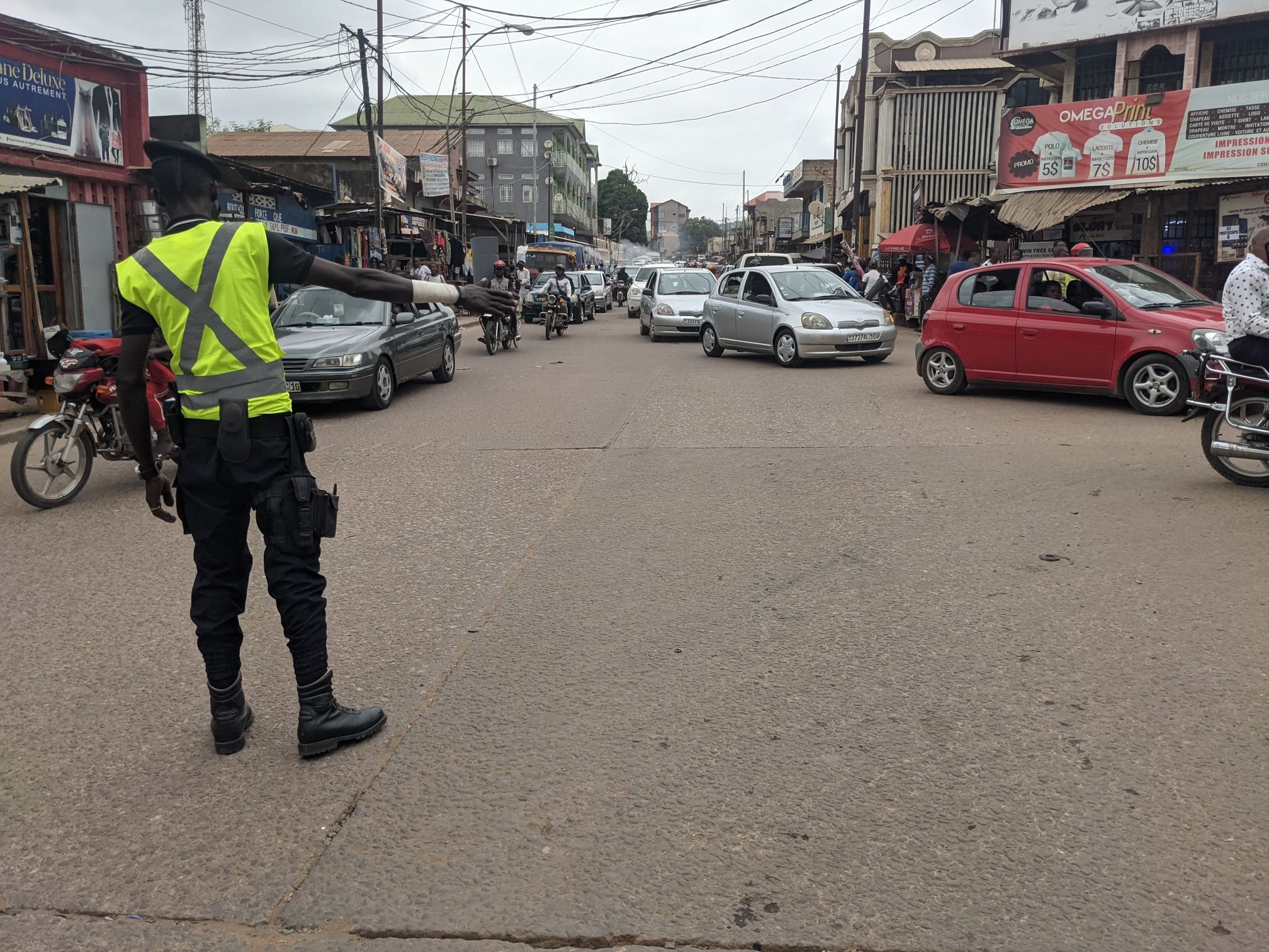
The road from the border into the city of Matadi was unpaved, and slow going as the various vehicles negotiated their way through.

The country’s main road, the RN1, runs through the city. It was absolutely crammed with vehicles. I didn’t envy the traffic officer trying to keep the junctions working.
There was a supermarket and I made my way there. The prices were pretty standard which seemed incredibly cheap after Angola. I stocked up on peanuts and peanut butter for a few days worth of protein. There was an ATM marked on iOverlander as giving USD, so I went there. It didn’t work for either of my cards, but I managed to withdraw Congolese Francs.
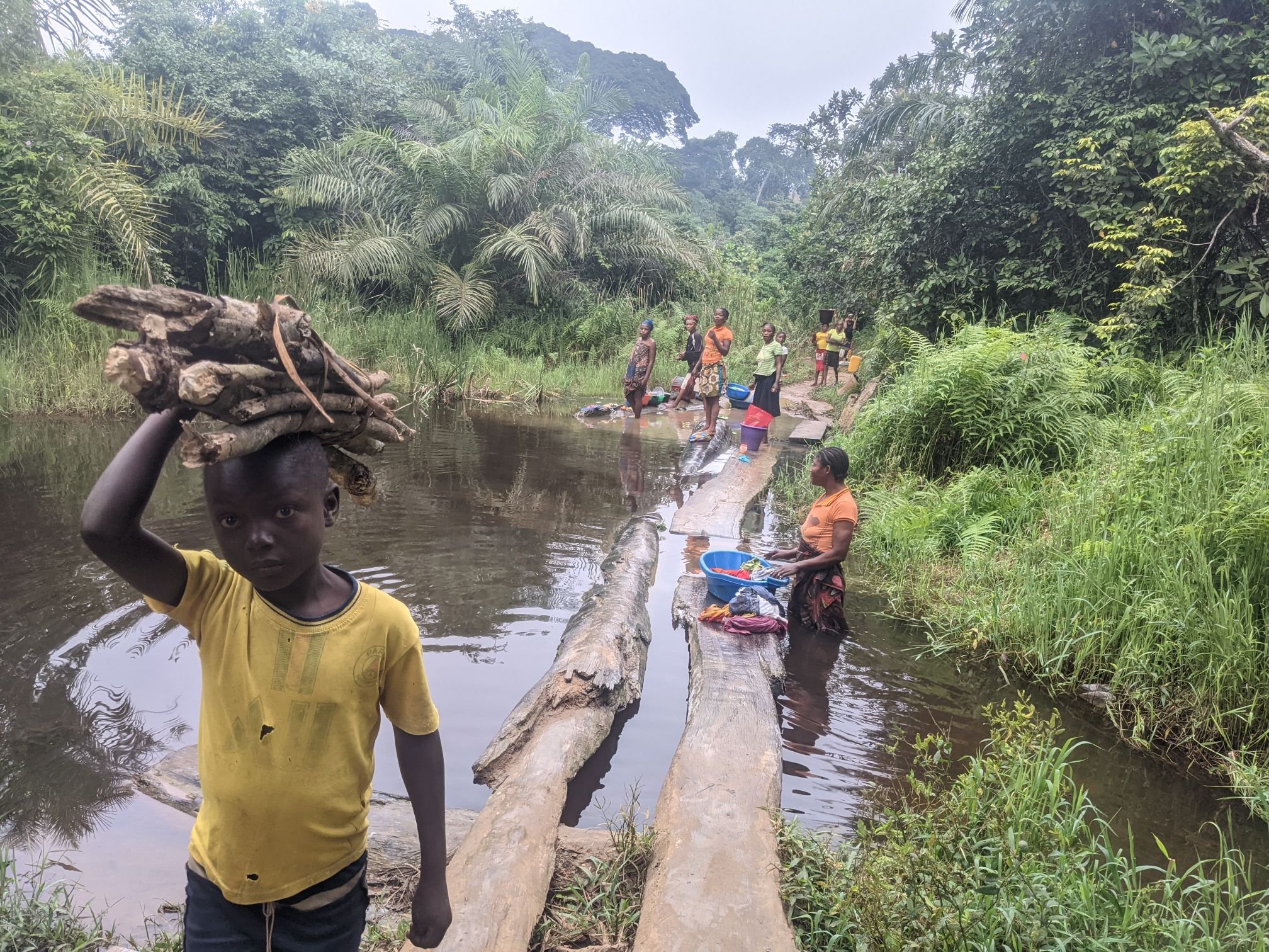
I rode down to the river, where I crossed the only bridge of the river Congo. It was an impressive structure. There was a toll – but not for bikes – so traffic immediately dropped off.


From the river the road climbed several hundred metres, descending at a few points along the way. There were villages quite frequently, and one of them was surprisingly large. There were lines of people on both sides of the road, 3-4 people deep. Some people stood in the road to force cars to slow while others swarmed around the vehicles trying to sell things. When I arrived, the number of people yelling Mbele was… Quite something. Someone hit me on the arm as I cycled past, hard enough to sting.
Having crowds of people yelling racial slurs at me while being hit isn’t my favourite thing, I have to say. Every vehicle feeling the need to honk as they pass wasn’t great either. In Angola I’d enjoyed cycling mostly on the tarmac roads, but now I was keen to get away. Which conveniently had been my plan anyway, so I turned off onto a dirt track.

This was a lot calmer. I saw the occasional motorcyclist but most people were on foot, women carrying backbreaking loads and men just carrying a machete, or on one occasion a hunting rifle. One man said something to me – the gist was that this wasn’t a main road. I said I only speak a little French, and by way of explanation added that I’m English. He replied (in French) that “We were colonised by the Belgians, so we speak French. We don’t understand English.”
I passed through a couple of small villages, where I still got a lot of attention but it felt less aggressive. In one, I took the wrong exit out of the village. I went back and took the correct one. People asked where I was going, so I had a look at a map to find the name of a town: Vanga.
They told me this track would go to Vanga, but there was a better way. I’m not sure if they meant going back to the main road and taking a different exit – which would be much longer – or if there was another route not marked on the map – which wouldn’t be surprising. I decided to stick with this one; at least when the track splits I can check the map.
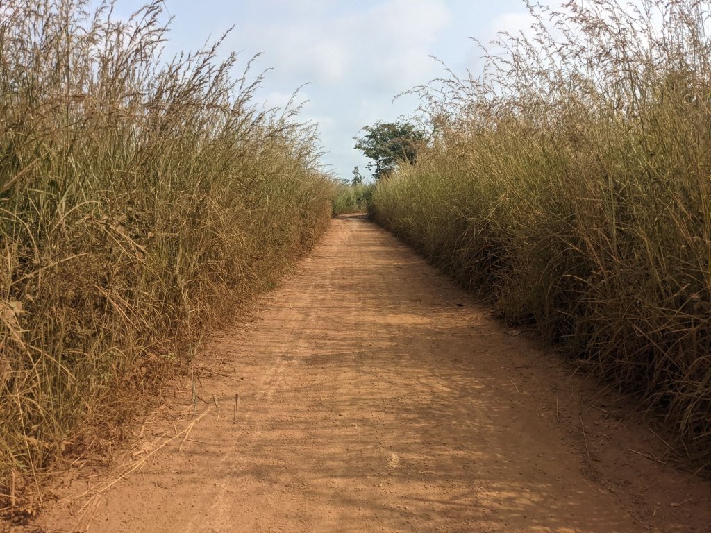
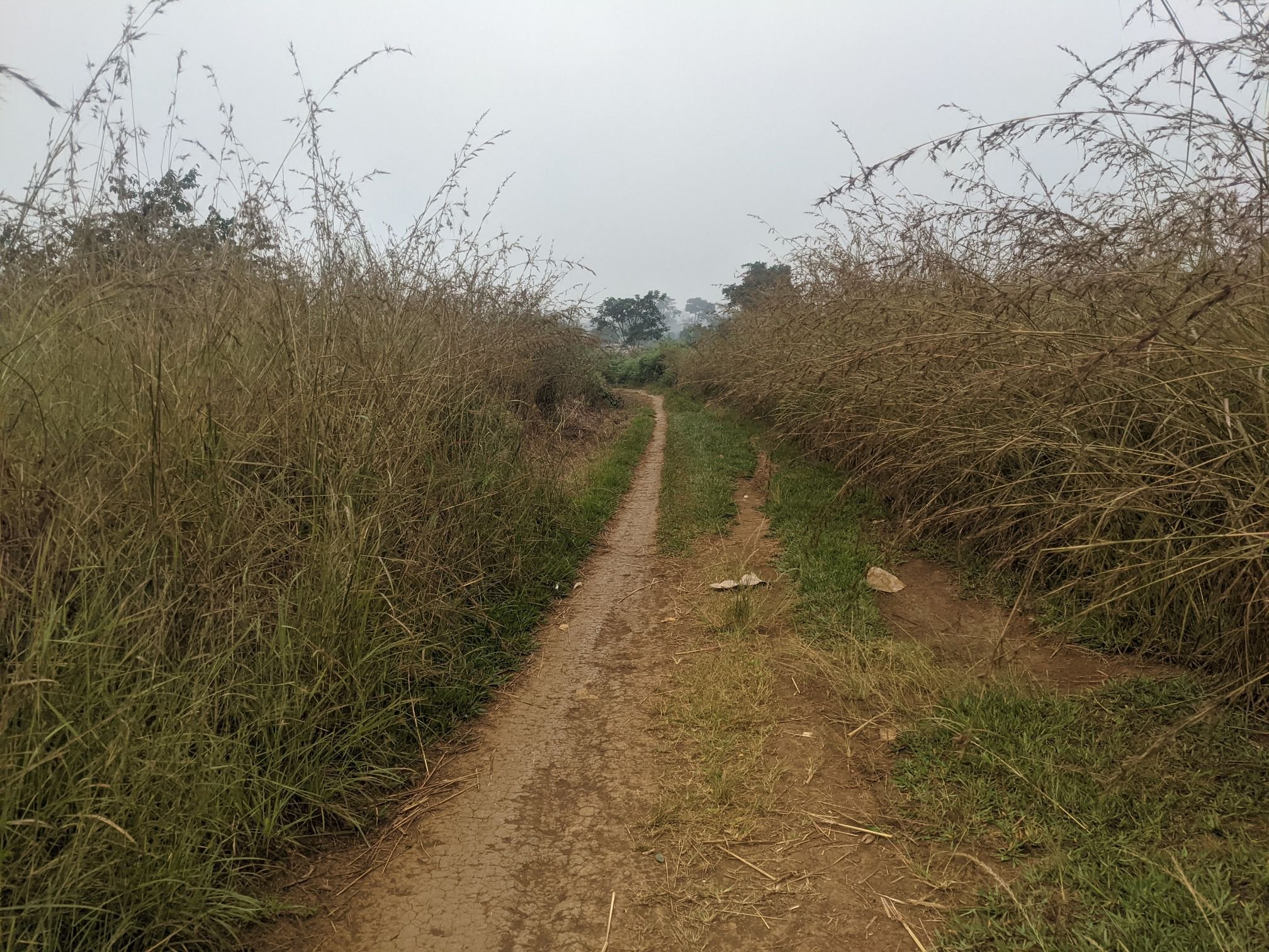
I could see why he recommended a different way. This route was narrow singletrack, and very overgrown. It was just about ridable.

This didn’t present many camping opportunities. Finally, as it was beginning to get dark, the track widened to such an extent that I could pitch my tent and people could still pass – though I hadn’t seen anyone for half an hour or so.

To my surprise, I heard a motorcycle some time later. I turned my phone’s torch on to make sure he saw me and didn’t simply ride over me in the dark; he passed without comment.
In the morning my tire was flat. But as I packed away my things a lot of small biting flies gathered. I pumped the tyre up and rode on a couple hundred metres before replacing the tube. While I was doing so, I looked up and was surprised to see a man walking toward me with a rifle over his shoulder.
Once I’d got the tyre sorted I set off cycling. I knew the track would be better after Vanga, in 16 kilometres, but there was a 200 metre climb before then that I’d be unable to ride if the track stayed like this. I was glad, then, that it joined a 4×4 track after about a kilometre.

The hill was slow going, being both steep and poorly surfaced. Children were walking to school and, whenever they saw me, they would stop. Once I passed, they ran along behind me. By the end of the hill I had quite a crowd. When I stopped to take a picture, the stragglers came running to be included, and teenagers pushed their way through the younger kids to be at the front.


The quality of the road was generally proportional to the gradient. Some of the flat sections had pristine gravel.
But flat sections were few and far between. Most of the time I was struggling up or down steep, bumpy tracks. Although the road was wide enough for a 4×4, usually only a much narrower section was ridable. This made passing the many motorcycles awkward.


It was generally ridable; I just pushed one climb. It was in the middle of the afternoon and particularly steep. It’s not especially hot here, but it can be very humid. Working hard to climb the hill while going so slow there’s no air movement, combined with sweat being unable to evaporate… I was overheating and opted to walk.

It is interesting how people change village by village. The first few hours, I was frequently called China (as well as Mbele and le Blanc) and greeted with “ni hao.” This barely happened at all later on. Similarly, in the afternoon I was chased out of several villages in a row by hordes of screaming children. This didn’t happen in the villages before or after.
I needed to lube my bike chain, and had an unusual problem of not being able to find anything to lean the bike against. There were no trees by the road, just long grass. In the end I just turned the bike upside down to do it. I needed to find somewhere where I wouldn’t be sitting in the main road, so I sat by a small track. I thought I wasn’t blocking the track but since kids were too scared to come within a couple metres of me, I moved further away.
In the late afternoon the road climbed to an elevation of around 600m. Higher up, the surface was significantly better – still bad, but not terrible. There was also less traffic.

Again, the jungle made wild camping a difficult prospect. Since this is, despite appearances, a main road, I didn’t want to camp on the road again. I decided to ask for permission at a village.
Around sunset I approached a village. Just outside the village proper, there were a couple of buildings with three men outside, sitting quietly and listening to the radio. I made my way over, introduced myself, and asked if I could camp. “Pas de problem” – no problem. Well that was easy!

They let the village chief know I was there, and he came over in the evening. He invited me to sleep inside but I opted to stay in my tent. There are a lot of mosquitoes and such around, and I’d rather be away from them. Quite a few people had followed the chief over and they stayed to stare at me, but the men on whose land I was camping chased them off.
I set off early in the morning and resumed yesterday’s role of pied piper, with all the schoolchildren chasing after me. At one point I stopped, to adjust something on my bike. Initially they flinched back away from me, then plucked up the courage to run past me and make a head start on the chase.


I reached a turning for a shortcut. It was marked as a more minor route on my map, but it was a third of the distance so it’d be faster unless I had to walk literally the entire way. As it turned out it was mostly of a better surface than the other track.

There was a village where I acquired another group of pursuers. It’s one thing when there were children, but here there were some men running after me. When they’re running a metre behind me on slippery, bumpy singletrack, if they trip I’d end up getting stabbed in the back with what are practically swords. When I judged it safe, I stopped and looked behind me. The whole group turned around and sprinted away in terror – including the armed men.
There were a few small streams, with planks of wood a metre or so long, used as bridges. They weren’t very stable so I walked over them straddling the bike. I then reached a larger river, where women were washing clothes. I carried the bike across a series of bigger planks, which wobbled worryingly as I crossed.
The track emerged onto another road, the RN12. RN (Route Nationale) is the highest road classification in the DRC, so one might expect the RN12 to be a motorway. Not exactly…


The pictures don’t really do justice to how bad it was. At one point the ridable section was about 30cm across, bumpy and sloping sideways. Foliage at eye level made it difficult to see the path. And on the edge of the 30cm path was a 2 metre drop. I opted to walk that bit.


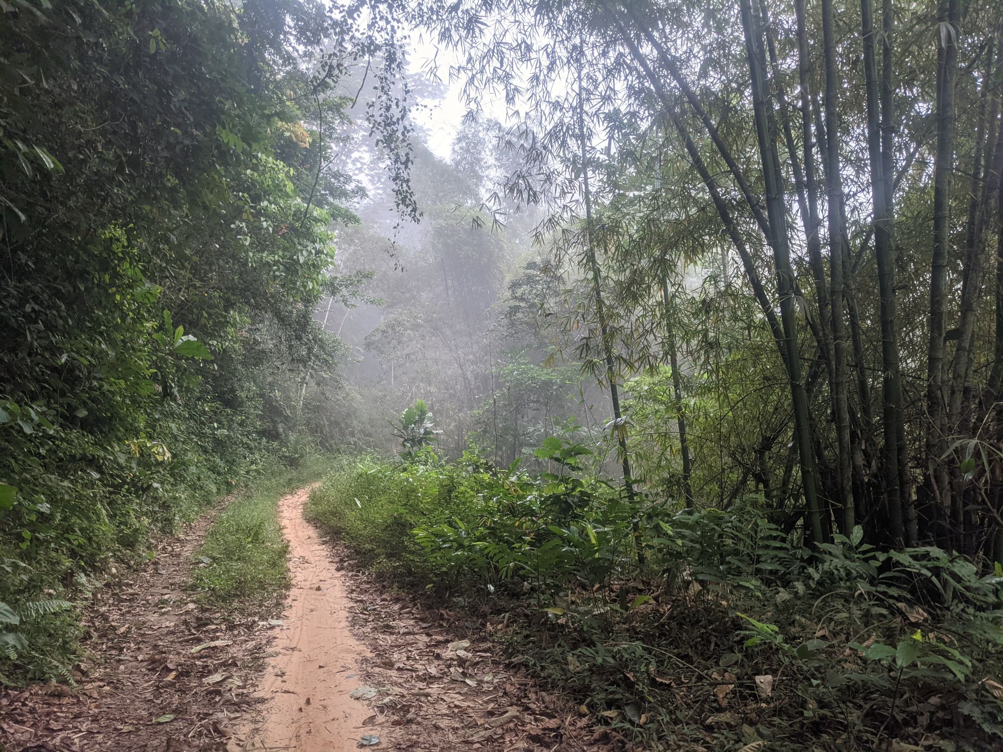
The road climbed, and it was slow going. Eventually I reached the top, and rode through a rainforest, which was worth the effort. It was pretty spectacular.

The road out of the rainforest was a little better, though it was quite overgrown and little used. Deep, narrow ruts had been left by motorbike tracks; in places they made pedalling impossible.


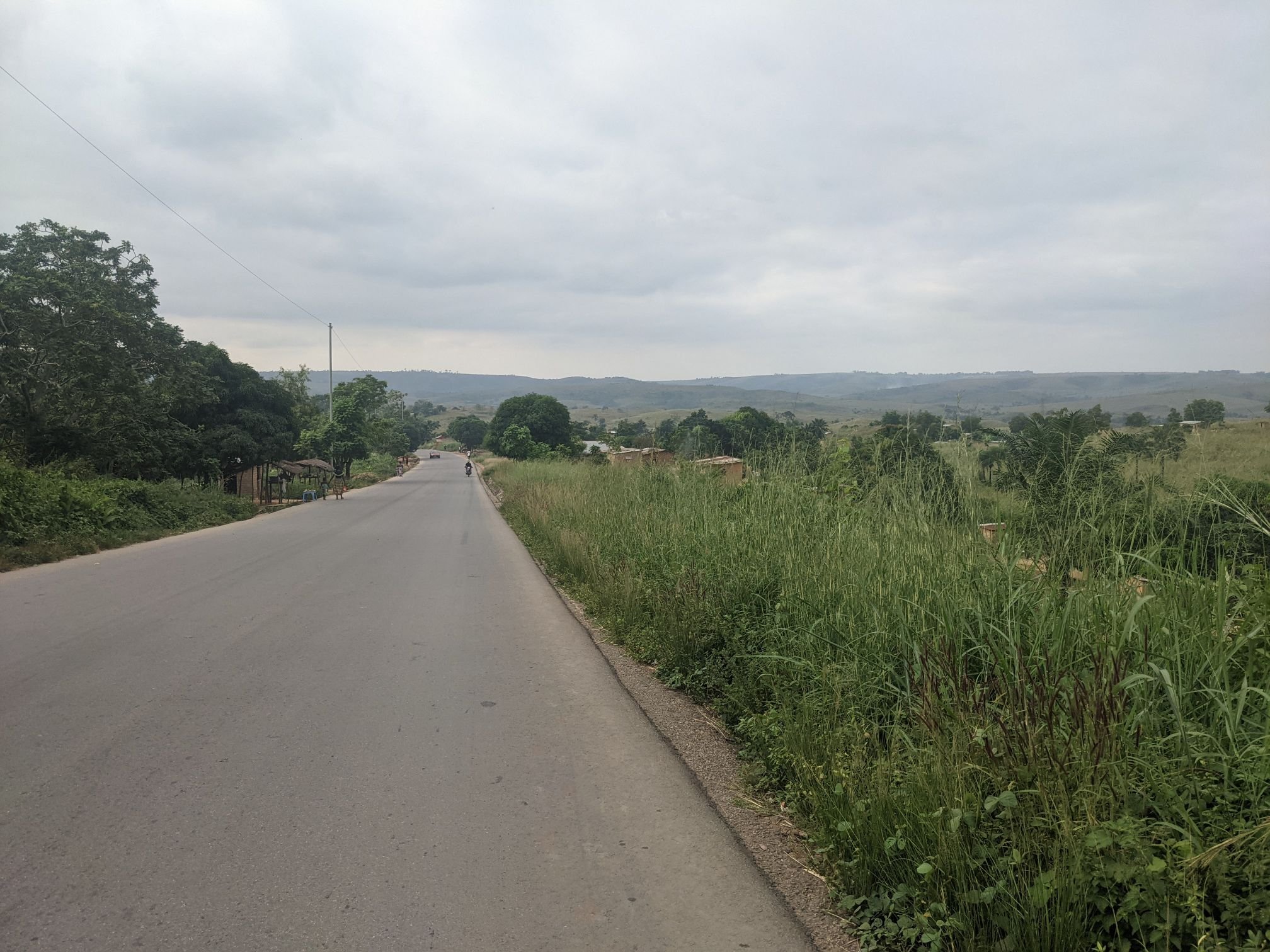
Past the village of Kilele, the surface of the road improved. There were a series of villages, and I was able to ride reasonably fast between them.


After a time the road climbed up to a pass, after which it would descend and I would leave behind the highlands and the rainforest.


Atop this hill, there were some men running a checkpoint, though they weren’t wearing any uniform. One had a look at my passport, asked some questions, then let me go.
The road widened for the descent but it was quite rough. The ground here is clay, which turns to mud when it dries out. When it dries it’s not one smooth sheet, but rather a lattice of cracks. It’s like riding on terrible cobbles; the whole bike shakes – and therefore so do I. It’s not fun.
I descended a few hundred metres and then the terrain turned to gently rolling hills. There are some long stretches of good gravel and the road in general is better.


The foliage here is less dense and there is some clear space near the road. In the evening I set up camp on a shelf slightly above the road. A few people went past, including men from the local village who asked a couple questions then left me be. After dark, a truck came past – a surprise since I’d not seen any operational ones during the day.

It was misty in the morning, a sign of the humidity. It was so humid in this area that for the first few hours of the day my phone had a notification warning of water in the USB port.

For the first hour or so, the road was very bumpy. I let some air out of my tyres, dropping the pressure to 25 PSI. The manufacturer’s recommended minimum is 50 PSI. The lower pressure helped a little.

The road began to improve, and as I cycled along a smooth gravel stretch, I saw a woman about 100m ahead of me. She saw me too and, flinging her basket of laundry away, she ran in terror. This was unusual – normally, when women flee from me (what a phrase…) they are careful to keep what they’re carrying balanced on their heads.

She caught up to a group of 10 or so other women and they joined her flight. As is common throughout Africa, the women carry their babies on the back, secured by a blanket wrapped around both bodies. One woman had to stop to adjust hers and the others stopped too, strung out in a line. As I passed the first few and greeted them with “bonjour”, they seemed to realise I was no threat and resumed walking the way they had been.
For the next few hours I was able to maintain a relatively decent speed. The surface was better and it was less hilly than usual. That’s not to say it was all easy, though.

Late in the morning I reached the town of Lwozi. Since leaving Matadi, this was the first settlement I’d seen that could properly be called a town. I had a look around some of the shops but as for food, they had little more than the biscuits sold in the small village shops.

Past Lwozi the road got back to its usual hilly self. To begin with the road was well surfaced and there was quite a bit of traffic, leading to a small village. One man there spoke a little English, so among the shouts of “Mbele,” there was a cry of “Gringo! Give me the money, gringo!” It’s been a while since I’ve been called gringo, though not long at all since people have demanded money.


Past the village the hills continued, and the road surface worsened significantly. I had to descend the hills almost as slowly as I climbed them. But there was almost no traffic, and good views of the landscape around me.


For the first time in quite a while, I stopped while the sun was still in the sky. At the top of a hill, there was quite a lot of clear ground. I picked a spot away from the road, and hidden from it by some grass. The reason the ground was clear is that it was quite exposed to the wind, which went some way toward keeping the mosquitoes away. It was the nicest campsite I’d had in a while.

The reason for my early stop is that I was just a few kilometres away from the village of Ndalatando. That’s where I’ll get stamped out of the DRC, and head over to the Republic of Congo. It’s about 75km from where I get stamped out to where I get stamped in, and I’d rather keep things simple by doing both on the same day.

May 25: 96 km
May 26: 71 km
May 27: 96 km
May 28: 96 km

Amazing!
Sam, how is the visa policy in DRC?
How did you get that visa?
Keep on going! What an amazing journey.
All the best from Italy,
David
LikeLike
Hey David! Hope you’re well. Are you planning an Africa trip?
The DRC can be an awkward one. Usually they only give tourist visas to people resident in the country that they apply from. But in Windhoek, they issue transit visas… That last for three months and let you stay in the country for 1 month. So basically the same rules as a tourist visa.
Sam.
LikeLike